Friday, May 18, 2018

Hike (part II)

On a lot of the tramping routes in New Zealand, the Department of Conservation maintains huts for people to stay in overnight. For a small fee, you get to sleep in a dry, warm location each evening. On some of the major routes, you have to reserve them in advance, but in most locations, they are first come first serve. We were on a pretty popular route, but not one that required reservations. There is always a slight chance the hut would be full when you arrived and you would have to tent camp or push on for the next hut (which would almost certainly be at least 3 additional hours of hiking.) We were there towards the end of the season, mostly on weekdays, so there was generally plenty of space. The one Friday night we stayed in a hut, it got pretty crowded.

The best hut we stayed at was the Upper Travers Hut the night before crossing the Travers Saddle. It was above the tree line and quite uncrowded. (For many hikers, meeting fellow trampers and socializing is an exciting and enjoyable part of the adventure. For some of us introverts, the "communal living" as Don called it, was more something to be endured. )
Upper Travers Hut

Inside the hut, there is usually a wood stove, and space for cooking. Depending on the size of the hut, there can be from just a couple to 30 or more bunk beds each with a sleeping pad. All you have to do is supply the sleeping bag. There is generally a source of rainwater. Outside, there are vaulted toilets. As can be seen in this photo, everybody is looking for places to hang all their damp hiking clothes to dry.
Common area in Upper Travers Hut

A gourmet dinner
Most of the huts had an outdoor deck with benches where people could put on their boots and get ready. In the photo below, the hut had a roof over it, though this was not universal. They all had a protected room where you entered. Presumably in bad weather, this is where you could shed your wet/rainy gear. It seemed that boots and hiking sticks were generally left out in this room. In the photo below, this is the small room visible through the window on the left. 

Getting ready to depart the John Tait hut

Nelson Lakes Hike

The centerpiece of our trip to New Zealand was the five day hike in the Nelson Lakes area. We scheduled with Southern Wilderness for their "gourmet" guided hike covering a part of the Travers Sabine Circuit. The red dashed line shows the whole Travers Sabine Circuit. We started at "1" in St Arnaud and took a boat to "2". From there we hiked from 2 through 5 and took a boat back to 6. The lower three of the huts with green circles show where we spent nights (we spent two nights at the hut at point "3".
The section from "3" to "4" was an optional day hike up to Blue Lake.


The hikers: Me, Mig, Don and an Australian lady named Norma:
Boat ride to trail head at beginning of hike


The guides: Angus and Toni. He is now the owner of the company having taken it over from the previous owner. They were both very friendly and seemed to enjoy what they were doing. It has got to be grueling, but satisfying work. They did all the cooking on the trip and carried nearly all the food. I tried picking up his pack at the beginning of the trip and it must have been around 60lbs.
Boat ride back at end of hike

The entire hike was probably 60-70km (40 miles). On 3 of the days we did a net 400-500 meters of elevation (not counting ups and downs in between). With a 25lb pack, I wasn't sure how tough that would be. It turned out just about right. Even though the distances weren't that long, the track was often pretty rough. We were walking along steep slopes, and clambering over roots, rocks and streams. There were a number of places where a stumble could have led to painful, possibly fatal consequences. A few shots of typical parts of the trail:

Roots, mud, tree trunk
Steep Slope

Roots, roots... there's a trail there somewhere...

... more roots... and more steep slopes...
The trails are maintained by the New Zealand Department of Conservation. Though rugged, they were generally well marked and had bridges at key points. We encountered several swing bridges which were my favorites. Usually, they are limited to one person on them at a time.
Single person swing bridge
Scree slope
We were in a mountain range called the Southern Alps which provided some beautiful scenery.
Climbing towards Travers Pass

Enjoying view shortly after crossing the Travers Saddle

On the second to last day, we had a day trip up to Blue Lake, one of the clearest lakes in the world (photo below). Behind Blue Lake, at the top of the ridge behind it is another lake. Water from this lake feeds into Blue Lake by filtering through hundreds of feet of earth and most of the particulate matter is filtered out in the process.
Blue Lake

New Zealand (Geology)


Before going to New Zealand, I had to do some research on the country's geology. Perhaps there were important geologic features to see or rock samples to gather...

Prior to 200 million years ago, New Zealand was submerged off the coast of Gondwana (a super continent made up of Australia, Antartica, Africa, India and South America). Many of its rocks formed from layers of sediment deposited on the ocean floor by runoff from Gondwana.

100 million years ago, New Zealand had risen above sea level and formed the coast of Gondwana, right next to Australia.

85 million years ago, it split off from Gondwana. At the time of the split, its plants and animals would have matched those of its nearest neighbors (Australia and Antartica). As time passed, though, they would diverge substantially.

Interestingly, the territory of New Zealand is split between two plates: the Pacific plate and the Australian plate. The boundary between them runs across the south island. The North island is entirely on the Australian plate. In the south, the two plates are sliding past each other (kind of like the San Andreas fault), creating the Southern Alps. In the north, the Pacific plate is being subducted under the Australian plate, creating a line of volcanic activity.


New Zealand plate boundaries (Image stolen from here on Wikipedia)

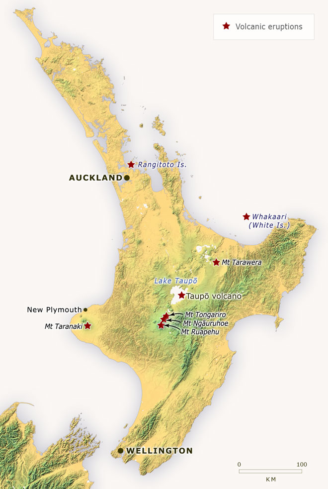
When one plate subducts under another, the sinking plate carries water down under the upper plate. As the water gets squeezed out of the lower plate, it causes the rock above it to melt and become more buoyant. The resultant magma migrates towards the surface giving rise to chains of volcanoes. (There is a thorough Wikipedia description here.) Hence, there are a number of volcanoes and a lot of thermal activity on the North Island. In the last several thousand years there have been a number of major volcanic eruptions. The Taupo eruption 1800 years ago is probably the largest eruption in the world within the last 5000 years. 


Here's a map of New Zealand's volcanoes (all on the North Island). 
Volcanic eruptions in New Zealand since 1300
Map of NZ volcanos (from here)
Both islands are prone to earthquakes with at least several minor quakes occurring each day. (They are mostly too small to feel.) Already in this century, there have been a couple large earthquakes on the South Island.

As future posts will hopefully show, a lot of the places we went to were strongly affected by this geology. Mountains, volcanoes and gold deposits all owe their existence to the collision of the Australian and Pacific plates.